


CHARLESTON, W.Va. — It appears the ‘warm wedge’ will have an impact on the massive winter storm moving across the country and set to hit West Virginia Saturday afternoon.
The National Weather Service has issued a winter storm warning for most of the entire state with 9 to 12 inches of snow possible in some areas.
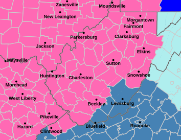
NWS Meteorologist Jennifer Berryman said the advance of the warm wedge from the south is expected to get into the southern coalfields and may even advance as far north as the Kanawha Valley or possibly the eastern mountains.
Berryman said there will heavy snow before the warm air gets here Sunday.
“It does look like it’s still going to be a pretty significant amount of snow if it does decrease some if we trend a little warmer,” Berryman told MetroNews Friday morning.
She said highest confidence for an all-snow event is around the Parkersburg area back into Ohio.
Berryman said the icing could be significant in the south, thick enough to cause problems.
“We are looking at a quarter of an inch possible, maybe even three-tenths of an inch and that can do some damage,” she said. “That could start causing some damage to trees and power lines.”
The snow will begin Saturday afternoon.
“We’ll be a little bit slower on the onset of things and then like the bulk of the moisture will be Saturday night into Sunday and then kind of tapering off from there as the system begins shifting away,” Berryman said.
The precipitation will be back to all snow by Sunday evening. The upslope effect will bring several more inches to the mountain counties. Behind the storm will be frigid conditions heading into next week.
The state Division of Highways said it has 1,000 snowplows ready for this storm. The agency said it also says it has enough salt and salt brine for the storm and can replenish supplies.
Morrisey does have a media briefing on the storm set for noon Friday.
Story by Jeff Jenkins, MetroNews